


Clicking any image in the slideshow above will open an enlargement in a new tab or window. Years 1956, 1976, 1989, and 1999 are sourced from the City of Burnaby Archives’ collection of orthophotographs, and stitched to create panoramas. The present day image links to a custom Google Map I created using municipal Town Centre boundaries. From this map, you can zoom in for detail, or out to compare Burnaby Town Centres amongst each other, and to others in the region.
It all began with a university village that never was
In the previous section, we found that Brentwood Town Centre grew out of a shopping centre. Conversely, the story of Lougheed Town Centre began with a visionary plan to establish a new municipal core surrounding a university district. But that plan fell through, and so like Brentwood, it also began with a mall.
In 1964, developer Western Pacific Projects presented a plan to Council authored by Project Planning Associates Limited. The plan proposed the development of a 1,619 hectare master planned community encompassing most of the northeast sector of the municipality, relating to the new Simon Fraser University.
The image below is from Planning Project Associates’ 1964 Simon Fraser Townsite Master Plan. The Google Map further below shows the area as it currently exists, indicated by the shaded blue area; the core area is indicated by the shaded red area.

View Simon Fraser Townsite Proposal in a larger map
The Master Plan was announced on the heels of the development of the new Simon Fraser University (a detailed timeline of the University’s development can be found HERE). The University’s location had been selected in 1963 by the Provincial Government on the recommendation of John B. Macdonald, then president of the University of British Columbia. Shortly after the recommendation was received, architects Arthur Erickson and George Massey (later known as Erickson Massey Architects) were chosen to plan the region’s second major University.
 The Simon Fraser Townsite was touted as a first-of-its kind community, designed specifically to be integrated with the new University. Aspects of this innovation were boosted by Mayor of the City of Vancouver, W. G. Rathie:
He pleaded a broad, long-term prospect subsidiary to the importance of the university. He said, “We are not just considering another shopping centre but what will be the industrial heart of the city.” In the past, he said, universities had been built in isolated areas but that, based on experienced disadvantages, the [Simon Fraser Townsite] Master Plan was designed to integrate the university in a development supporting the singular distinction gained by Burnaby through its university and its unique [regionally central] location.
It appears though, that Rathie had ulterior motivations for his support: his City owned a large parcel of land that was at one point dedicated as cemetery overflow lands. The prospect of a future massive rezoning on the slopes of Burnaby Mountain would have proved to be a windfall for Vancouver’s coffers.
At the same time that this project was in the planning stages, another firm had approached Burnaby planners. In late 1964, the planning firm of Dirassar, James & Jorgenson sent a letter to Director of Planning Tony Parr, indicating an intention to rezone a 12.55 hectare parcel of land at the corner of North Road and Lougheed Highway. The clients, Jack Aceman, Monte Nathanson, and Sam Rosen, proposed the construction of a shopping centre accompanied by community amenities and offices.
Parr quickly responded to Dirassar, James & Jorgenson, reminding the developer of the existence of the Simon Fraser Townsite plan, but clearly not dissuading them from presenting their proposals to Council. Shortly after this, Parr wrote to the Lower Mainland Regional Planning Board, seeking their input on the potential Dirassar plan for a regional shopping centre. Feeling threatened by this move, Project Planning Associates Ltd. wrote to Parr, expressing concern over the negative impact that the Dirassar plan would have on the Simon Fraser Townsite. Shortly afterwards, Parr also received a letter from the firm responsible for planning Simon Fraser University. Replying to a letter Parr sent earlier soliciting opinion on the market status of the City of Vancouver’s land on the mountain, George Massey, of Erickson Massey Architects, denounced the Dirassar proposal and argued in favor of Project Planning Associate’s plans to bring a commercial centre closer to the University.
By March 8 of 1965, it was apparent that Burnaby’s Director of Planning was already leaning towards a preference. On that date, he sent a letter to the Hudson’s Bay Company, hurriedly wishing to know if the company would consider establishing a department store in the North Road-Lougheed Highway (Dirassar) shopping centre regardless if the Simon Fraser Townsite was established. The letter was seemingly so quickly written that Parr even apologized, saying “please accept my apologies for the haste, and abrupt nature of the questions.”
A shopping center village
Much to the disappointment of the Simon Fraser Townsite proponents, on October 1 of 1965, the municipality signed an agreement with Lougheed Shopping Centre Limited (a firm that appears to have taken over the development from Jack Aceman, Monte Nathanson, and Sam Rosen). While one would think that the name Lougheed came from the adjacent highway, they would be mistaken. According to media reports concerning a 1988 inheritance court case, it was noted that Lougheed Shopping Centre Limited was actually an endeavor by a partnership of companies controlled by Bill Lougheed, his brother Gordon Ellsworth Lougheed, and Jack Brown, of the Brown Bros. automotive firm. The highway on the other hand, was named after Nelson Lougheed, B.C.’s Conservative Public Works Minister in 1928. Nelson Lougheed had promoted the construction of the road to link a lumber mill he owned in Port Haney.
The $17 million shopping centre proposals were described by architects as an “elegant lady mall” owing to a facade composed of “curved pale walls” and “intimate wooden canopies.” It was expected to be fully air conditioned (unique for the time), and contain two levels. In addition to anchor tenants Safeway and Hudson’s Bay Company, the shopping centre was also expected to house a year round ice rink and two cinemas housing 1,900 seats in total. The shopping centre was first expected to commence construction on September 15, 1965, but by the time the developer received Council approval, it was announced that construction would be delayed. Despite a ceremonial ground-breaking on November 26, 1965, construction tenders were not expected to be sent out until the following April, marking an anticipated completion date for September 15, 1967.
In 1966, the municipality produced a report titled North-East Burnaby Study.The  document was subtitled the Revised Simon Fraser Townsite Plan, which was a misnomer as Project Planning Associates was no longer involved with the municipality’s preference for a Lougheed Highway-North Road Shopping Centre. Nonetheless, the municipality cribbed many of the concepts from the Project Planning Associates’ plan, and applied them to its revised plan. Among those concepts were:
- A major cultural and commercial centre
- A convenience sub centre (locally serving shops)
- A series of neighbourhood units (an urban structure hierarchy)
- High density residential development (sloping downward from the core)
- A continuous park and open space system
- A system of major roads (converging in the core; connected to the University)
The revised plan also took into consideration accommodation for the pedestrian movement that would be required by children walking to and from local elementary and high schools. The report called for a network of grade-separated pedestrian crossings, outlining a fairly complex pedestrian network across the Town Centre:
In order to create optimum safety and a measure of residential amenity within each neighbourhood a system of park walkways is proposed that will link the residential areas to the elementary schools and neighbourhood playground. These park strips provide the pedestrian with a minimum of disturbance from motor vehicles and have the added advantage of relating active and passive park areas […] Where varying densities occur within a neighbourhood the park strip and park areas may define the zones of varying densities in order to buffer and to preserve the character of each type of residential accommodation well as provide pedestrian access to commercial centres.
Within the revised plan, planners also noted that the establishment of a “prestige department store” would need to be met as a condition for the development of the Lougheed Shopping Centre. This was especially interesting, considering what was at stake in addition to the shopping centre. Developers were also responsible for the Lougheed Village, a massive development area including apartment towers and low-rise condominiums. But, despite the municipality’s covenant and the developer’s earlier assurances, it appeared that construction delays may have been attributed to difficulties in securing the Hudson’s Bay Company department store. The issue appeared to have become so dire, that in 1967, Council indicated that they would defer rezoning of the shopping centre pending a telegram from the Hudson’s Bay Company guaranteeing their presence in the development.
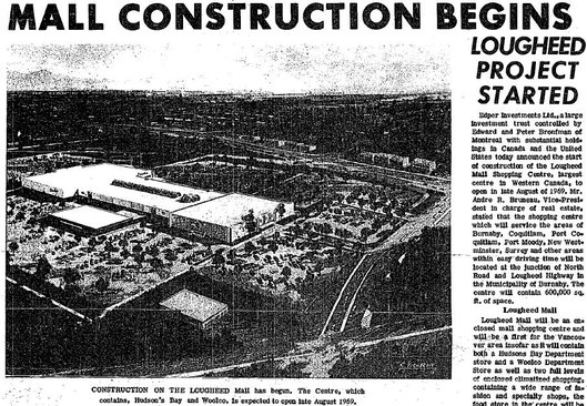 By June 6, 1968, Montreal-based developer, Edper Investments Limited assumed control over the Lougheed Shopping Centre project. It was touted as the largest centre in Western Canada. Edper had secured Hudson’s Bay Company as an anchor tenant. The department store was also joined by American discount department store Woolco. The shopping centre was opened on Edper Investments’ revised schedule in late August of 1969. Construction of the surrounding residential areas also proceeded on schedule, resulting in the high density form we find today.

The area appears to be strongly inspired by the distinct styling of renowned Canadian Architect Arthur Erickson. The original Simon Fraser Townsite Plan was abandoned, but the Lougheed Town Centre retained many of the original plan’s elements.
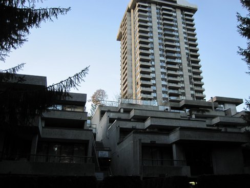
This type of sloping design is very common throughout the area. Stairways cascade over each other, winding seamlessly into wooded pathways interrupted by the occasional planted flower bed. There is also a strong emphasis on natural forested areas; many creeks run through the area, some of which are active salmon bearing streams and cared for by active stream-keeper groups.

The pedestrian paths are an ongoing subject of renewal and improvement. In 2008, the municipality invested $280,000 to improve a pedestrian pathway that crosses beneath the busy Lougheed Highway. This pedestrian pathway is heavily used by residents to traverse across the area to connect to the shopping centre and transit. The photo below shows the pedestrian underpass, and the photo further below shows the highway above.


In many ways, this Town Centre seems to most closely resemble the aspirations described in the Apartment Studies: a fairly strong pedestrian grid, calm residential traffic areas, a majority of parking located in a network of underground parkades. There are also various locally-serving shopping areas normally accessed by foot.
There are significant drawbacks however. Despite occasional renovations over time, the shopping centre seems to have become the Town Centre’s hole in the donut. Several walking paths lead from the surrounding residential areas to the shopping centre, but pedestrians are met with a hostile paved lot with a 3,000 parking space capacity. The mall itself is exclusively occupied by retail uses. The ice rink that was proposed earlier was never built, and the cinemas that were built have since been converted into additional retail. The shopping centre is also devoid of any significant office space. The Cameron Recreation centre and Library is one of the few non-retail destinations within the Town Centre. But, there are strong indications that this may all change soon.
Rapid transit sparks Lougheed’s imagination
In the previous section, we found that the Brentwood Town Centre Development Plan was initiated in large part to assist municipal officials to lobby for a Lougheed Highway rapid transit alignment. For Lougheed Town Centre, the transit question was always much more certain. Nearly every proposal put forward for a transit option connecting the Northeast Sector contained some sort of intersection through Lougheed Town Centre. Prior to rapid transit, there was a heavily used bus loop located to the east of the Lougheed Shopping Centre. This loop offered connections between Coquitlam, Port Moody, New Westminster, Burnaby, Vancouver, and Simon Fraser University. So the question was not if, but when and how.
As we found in previous sections, the Mike Harcourt New Democratic government was prepared to finance a rapid transit line in the mid-1990s. The Brentwood Town Centre Development Plan was engineered to make the case that it would be beneficial to bring a transit line where it had the most potential to shape future growth, versus serving established neighbourhoods. By early 1995, with a rapid transit line imminent, Burnaby’s Mayor William Copeland further bolstered his municipality’s case by outlining the process for a proposed Lougheed Area Advisory Committee. By late 1995, the Greater Vancouver Regional District and the provincially-partnered Vancouver Regional Transit Commission reversed its support from an earlier New Westminster-Coquitlam alignment to a Lougheeed (Burnaby)-Broadway (Vancouver) alignment, signalling endorsement for Burnaby’s preferred route. This proposal was planned to be followed by a phase two connection from Lougheed Town Centre to the Northeast Sector, though it did not pass without opposition.
Coquitlam’s Mayor Lou Sekora decried the Lougheed-Broadway line as a “terrible waste of money […] meant to boost Burnaby’s dying malls,” predicting that funding would dry up before construction would begin on the Coquitlam extension. Richmond’s Mayor surmised that the vote was the result of B.C. Transit studies which surfaced “after the [Provincial] government appointed Burnaby councillor and NDP activist Derek Corrigan as chairman of B.C. Transit.”
Dismissing critics, Burnaby’s Mayor Copeland lauded the regional endorsement, noting that “it would be good for business at both malls [Lougheed and Brentwood] and all other businesses along there.” The manager for Lougheed Mall stated, “we recognize that wherever the LRT concept goes there are usually some sales rewards as well as other land site opportunities.”
In 1997, Burnaby released the Lougheed Town Centre Plan. This plan was unlike the Brentwood Plan, an area that was essentially a blank slate in the eyes of planners. Lougheed Town Centre was already chiefly built up, so the plan instead suggested surgical changes. One of its key recommendations involved the vision of a new Town Centre core – on the site of the Lougheed Shopping Centre. The plan called for a complete overhaul of the mall, applying a much finer urban fabric, and focusing the area around the expected transit station. The plan called for an additional 3,700 residential units on top of the existing 6,200. Of those, 2,400 would be absorbed into the core, “with about three-quarters of these within a mid to high rise form.” The plan also envisioned a massive influx of commercial uses. It estimated that the present complement of commercial space in the Lougheed Town Centre was about one million square feet, of which half “relates to Lougheed Mall.” The plan proposed:
[…] the eventual development of an additional 2 million sq. ft. of commercial space. Of this, 1.8 million is in the Core Area and will be in the form of major office, hotel/ convention and street commercial space. These proposals will take advantage of the benefits that will arise from the introduction of two LRT lines that will converge in the Town Centre […]
Below left is how the Town Centre appears today. Below right is an arist’s rendition of the 1997 Lougheed Town Centre proposal.

The plan called for a transit station at the corner of Austin Avenue and North Road, approximately where the bus loop had previously been located. The station would be integrated with the existing mall, forming the nexus of the pedestrian paths that would result from placing parking underground. The site would also be suitable for a gateway into the Northeast Sector, owing to its location straddling the boundary between Coquitlam and Burnaby. Below is an artist’s rendition of how this area was envisioned.

SkyTrain comes to Lougheed
One year following the Lougheed Town Centre plan’s final release, regional discussions concerning the preferred at-grade rail option began to falter. In 1998, Premier Glen Clark announced that the at-grade light rail transit (LRT) option would be replaced by the same advanced light rail transit (ALRT) SkyTrain technology that already existed. Clark cited rancorous issues in negotiating with municipalities, citing modifications such as overpasses and underpasses and construction timelines as threats to the project’s budget. Also, considering that Clark was in an election year during an already embattled period, local media cited that the Premier was attempting to court various rapid transit providers, eventually settling on SkyTrain’s Bombardier because of a promise the company made to establish a local assembly plant. Others however, mused that the change from at-grade LRT to ALRT was the result of a government seeking to employ hundreds of unionized tradespeople whose support could later be counted on at the ballot box.
The groundbreaking for the SkyTrain line at Lougheed was met with very little fanfare. Jenny Kwan, Minister Responsible for Transit, was joined by only a few elected officials, notably excluding Coquitlam’s Mayor Lou Sekora. The event took place one day following the Greater Vancouver Regional District’s vote to officially indicate its dissatisfaction with the location selected for the Lougheed SkyTrain station. In a bid to ensure the project ran on time and on budget, the crown corporation responsible for the SkyTrain project, Rapid Transit Project Office, indicated that a station on the proposed Lougheed Town Centre bus loop was not feasible. The Project Office indicated to the Lougheed Shopping Centre’s owners that the cost of extending the station out to the front steps of the mall would require a payment of $20 to $25 million. The decision to abandon that site meant that the station would no longer straddle the Burnaby-Coquitlam border as earlier planned, but instead be located on a less desirably site on the southern border of the Shopping Centre in Burnaby. This decision caused even Burnaby officials to voice their displeasure.
In retaliation against the Rapid Transit Project Office’s move, the Ontario Pension Board, owners of the Lougheed Shopping Centre, sought to deny the province access to construct transit infrastructure on the southern boundary of their property. The management company for the Lougheed Shopping Centre claimed that a bus interchange at this location would have a detrimental impact on their tenant, a Sears Outlet store. The province was eventually forced to expropriate the required land (this explains the station’s overall awkward configuration and poor relationship to the surrounding area). Eventually, the Lougheed Shopping Centre owners constructed a covered walkway linking it’s entrances to the SkyTrain Station.
Click on highlighted polygons to find out more. // View Lougheed Town Centre SkyTrain Station in a larger map.
The New Democratic Provincial Government faced a spectacular defeat during the 2001 election. Only two New Democratic Party members survived, shelving the next phase of rapid transit expansion. As a remembrance of the plan, an empty concrete guideway still exists at the Lougheed Town Centre Station, collecting weeds and debris.
Another opportunity for a renaissance
In 2008, the Liberal Provincial Government resumed talks to extend a rapid transit line to Coquitlam and the Northeast Sector. Despite earlier technology considerations in the final months of the New Democratic Government, the Liberal Provincial Government announced that SkyTrain technology would once again be selected, putting to use the earlier abandoned concrete guideway.
 In anticipation of the line’s construction, the City of Burnaby saw an opportunity to begin realizing the earlier Lougheed Town Centre plans, permitting redevelopment of an area on Cameron Street and North Road. Council expected the Evergreen Rapid Transit Project Office, the crown agency charged with the line’s construction, to include a Cameron Street Station into the plans. However, citing a $70 million cost as being too prohibitive, the City was told that a Cameron Station would not be included in construction plans. Instead, the line was proposed to run from the existing Lougheed Town Centre SkyTrain Station and up North Road without a stop until the Burquitlam shopping plaza, well outside the boundaries of the Lougheed Town Centre core. Despite ongoing rancour from the City of Burnaby, as of early 2012, plans do not yet show a Cameron Street Station.
In 2010, Shape Properties purchased the Lougheed Shopping Centre from previous owners, Ontario Pension Board Realty. The sale occurred near the same time that Shape acquired the Brentwood Shopping Centre, maintaining the historic pattern of single-ownership for both malls. As we noted in the previous section, the Brentwood Town Centre is currently on the cusp of a massive renaissance, led by Shape Properties. Although major announcements have not yet been made, it would not be surprising to hear if in the near future, that Shape Properties makes a major announcement regarding the redevelopment of the Lougheed Shopping Centre. Much like the Brentwood Town Centre discussions, it would not be strange to expect a development proposal that resembles characteristics of the Lougheed Town Centre plan: a plan that echoed principles from the revised Simon Fraser Townsite and the Apartment Studies of 1966 and 1969.
Conclusions
In this and the previous section, we covered a detailed history of Brentwood Town Centre and Lougheed Town Centre. As we found, the histories of both have followed quite different paths, though they arguably have both arrived at the same current state. They were both founded by visionary long-term plans. They were both established with shopping centres at their cores from a very early point. The shopping centres have formed their contemporary, albeit awkward core, and now present a defining moment in their history to realize the potential of the Town Centre concept.
The history of the two remaining Town Centres follow a very different path. The first Town Centre we will look at was established fairly late, but offers an interesting look at the extent of public participation in building community plans. And, the final Town Centre we will look at provides an extraordinary glimpse into the machinations of urban politics and development. The future of both however, can not be understated. They each provide the same results as the previous two Town Centres: an interesting insight into the potential of the Town Centre concept to redefine suburban spaces.
>> Continue reading onto the next section: Edmonds Town Centre>>
Great website.
Shape properties has a massing diagram on its Lougheed Leasing Brochure, here:
http://www.shapeproperties.com/sites/default/files/brochures/LTC%20-%20Brochure%20-%20January%2012,%202012.pdf
that’s a very illustrative brochure you attached. thanks.
Regarding Edmonds, I read that the SkyTrain station was an “afterthought” and was added late in the project. Was there ever any thought to diverging from the interurban RoW and using the hydro corridor for SkyTrain, with a station closer to Middlegate Mall on Kingsway? As built, there are two nodes to the Edmonds area, one on Kingsway and one at the station.
I have heard and read many times that there was a plan that the skytrain line would split around edmonds, and a line would go up edmonds, with a station at Middlegate, and continue through centreal burnaby to North Road, I think. The idea was abandoned for cost reasons, I would imagine, and also because the existing densities were low and the potential for massive development was rather remote.
I wrote a bit about this subject in the section on Brentwood Town Centre (http://davidpereira.ca/projects/burnabys-town-centres/brentwood-town-centre/) – look at the Google Map about half way down the page under the heading, “Transit sparks a renaissance”.
See the link (http://davidpereira.ca/wp-content/uploads/2012/01/1991-07-03-CoB-Proposed-SkyTrain-Extension-to-Lougheed-Via-BC-Hydro-Right-of-Way-through-Rober-Burnaby-Park.pdf) for a municipal council report from 1991. That report was written as part of Burnaby Council’s intention to prevent a line from cutting through Robert Burnaby Park. As I understand it, under the Social Credit Party, the Province had selected that route as the cheapest option to connect to Lougheed Town Centre – cheap because BC Hydro already owns the power line right of way that passes through most of that route, originating from the Newell Substation at Kingsway and Edmonds.
Keep those comments coming!
Thank you David for your excellent research on the Lougheed Town Centre.
Today I hosted my UBC Housing Policy students (community planning and architecture grad students) on a bus tour of LTC, UniverCity and Port Moody (NewPort Vllage and Suter Brook). This was an excellent resource as I have emphasized with my students that contemplating the future requires an understanding of the past.
Thanks again and I have shared this link with my students.
Great write up. I used to live in the area and always wondered if the street named “Erickson Drive” was in any way related to arthur Erickson, perhaps as a nod to Arthur Erickson. Do you have any details on this?
I apcpreiate you taking to time to contribute That’s very helpful.
Thank you so much for compiling this!